On 9th July 1867, a group of Gentlemen met at 3 Eglinton Terrace in Glasgow’s Southside and formed Queen’s Park Football Club. This event recorded at 8:30pm is the ignition switch for a sequence of events, which would spread football throughout Scotland and subsequently the world.
If you look for 3 Eglinton Terrace today on a map you will not find it. Over time, and throughout the last 150+ years, there has been massive upheaval in the landscape of the Govanhill, Queen’s Park and Crosshill areas. For example, at the time of the meeting, Eglinton Terrace was in the Victoria Road area, but outside of Glasgow City’s boundaries.
There have been countless attempts to prove the location of 3 Eglinton Terrace. The theories were based on all known available information, including Post Office Directories, title deeds, and census information, and concluded 3 Eglinton Terrace was today known as 404 Victoria Road. However, there was one key issue – there was no map available showing this location proving this definitively.
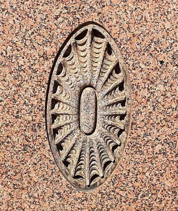
Richard S. Young, author of ‘As The Willow Vanishes’, set out on a mission to map the true location once and for all, and joined forces with The Hampden Collection on 9th July 2022. On that day, The Glasgow Football Tour created a special Queen’s Park Walking Tour around the 3 Hampdens. This tour included a journey around Victoria Road, where both Richard Young and Graeme Brown explained the mission to find Eglinton Terrace and to show the key markers which merited further research. One such marker was the inexiplicable spider’s webs carved into the granite fascias of the Bank of Scotland on the corner of Victoria Road and Prince Edward Street. Could this reference to the Queen’s Park’s nickname of ‘The Spiders’ be the key to this mystery?
The first research point following the tour was to determine the age of the buidings on Victoria Road. The site deeds for the buildings on the West side of Victoria Road showed that the land was purchased by William Menzies in 1863, and was a two acre plot running from Allison Street to Albert Road. These new tenements which Menzies built were called Eglinton Terrace and marketed for rental from 1864.
This research led to the following maps being discovered with the brilliant help of Michael Gallagher and the Mitchell Library City Archives Team. They have kindly given us permission to reproduce these images for the world to see.
The first map of relevance is the 1871 tramline map of Victoria Road. This is hugely significant, as it shows clearly Winton Terrace exists on the east side of Victoria Road, however there are no tenement buildings on the West Side.
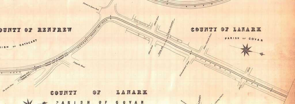
Furthermore, within the British Buildings Listings classification, 404 Victoria Road is listed as ‘1880s Thomsonesque’ design. This research disproves the existing theory, as these buildings did not exist in 1867, and therefore 3 Eglinton Terrace had to be somewhere else.
These findings triggered more extensive research to be made, and with the support of The Mitchell Library’s City Archive staff, the following deed map was unearthed from within a bundle of trust papers of William Menzies.
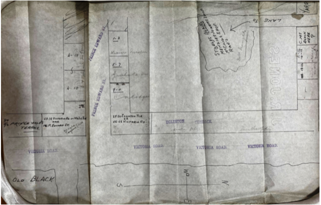
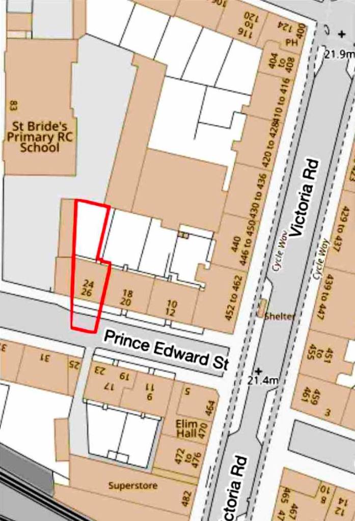
This map clearly designates No. 3 Eglinton Terrace on what is today called 26 Prince Edward Street, which ran adjacent to Hutchesontown Gardens. This also shows how 1-12 Eglinton Terrace was built on Prince Edward Street and 14-22 Eglinton Terrace was built on Allison Street, before the rest of Eglinton Terrace was built on Victoria Road. This also explains why Eglinton Terrace is listed as being both within the Crosshill and Queen’s Park burghs in the Post Office Directories, as the burgh boundary bisects the two acre site.
This is the first ever map discovered with 3 Eglinton Terrace listed. However, there was one more map required to substantiate the theory and this is from the same 1879 railway map, which was used by Graeme Brown in 2017 to discover the 1st Hampden Park.
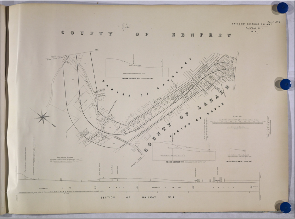
Following a careful inspection of this 1879 railway map, the buildings on Prince Edward Street are designated by their logbook references.
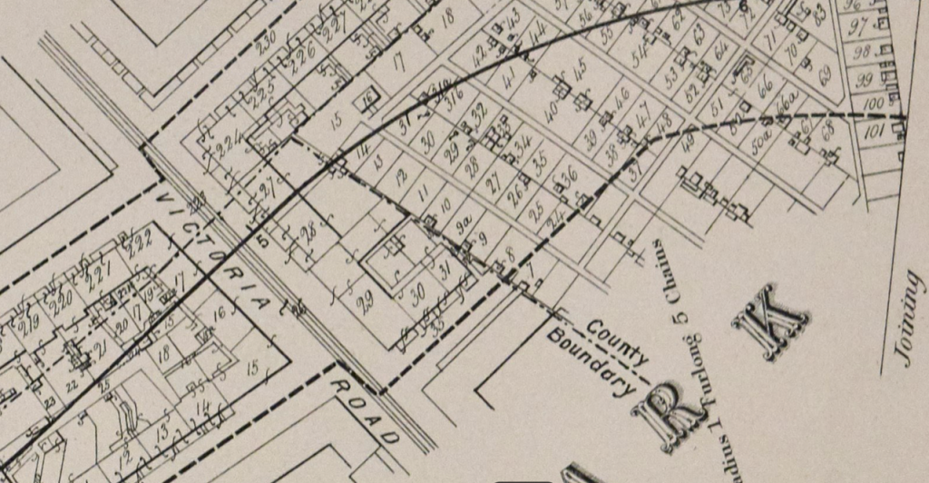
This diagram shows the buildings marked in the logbook as items 29-31, which correspond to 4-12 Eglinton Terrace in the trust deed map. This shows the buildings were in situ in the same proportions as the deed map for Eglinton Terrace and were overlooking Hutchestown Gardens.
The Trust Deed Map, Tram Map and Railway Map have been overlayed into one image to show how they align.
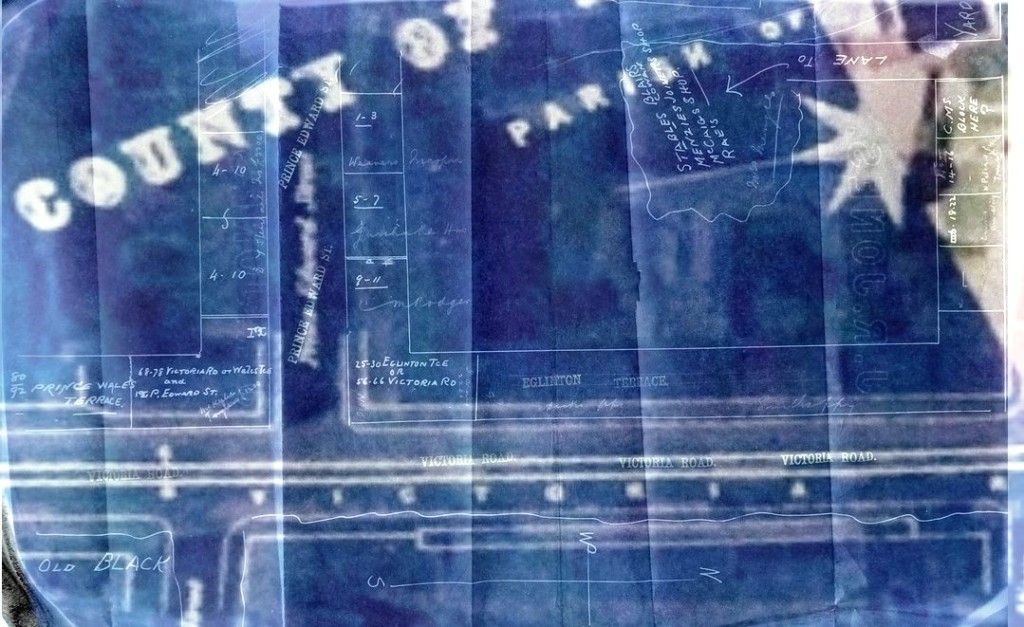
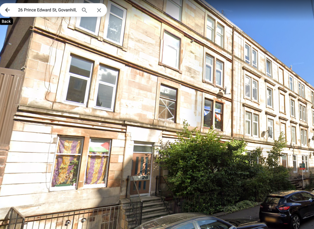
This image proves definitely the location of 3 Eglinton Terrace, which today is known as 26 Prince Edward Street. This is shown in the deed map and street view below, which faces the Bank of Scotland and those spider’s webs. Those markers were the key to finding 3 Eglinton Terrace.
This extensive research completes the 21 locations within Football’s Square Mile, and will hopefully lead to further investigation into the lives of Queen’s Park’s members; and why they chose this location for their first meeting.
The Hampden Collection Team will now proceed for recogntion of this hugely important site as part of its UNESCO World Heritage Campaign.
*** This information was published at 7am on 21st August 2023 ***
